Explore the Antarctic through the eyes of a Chartered Surveyor as he charts his way across the rock, snow, ice and frozen sea of the Antarctic Peninsula.
I qualified as a Chartered Surveyor in 1973. There are many types of surveyor who survey in different things but before I mention some of these you need to know that the word ‘Survey’, simply means ‘to measure’.
So, for example a Quantity Surveyor will calculate (or measure) all the building materials to be used on a building project (bricks, concrete, roof tiles, floorboards, doors, windows etc). These can then be ‘priced’ or costed so that the builder knows how much the new building will cost to build. A marine surveyor will survey ships to make certain that they’re ‘seaworthy’.
I’m a Land Surveyor so I’m involved in measuring land and part of my job involves the ‘setting out’ of new building or civil engineering work. At the beginning of any large construction project, all that there is, is a large piece of land where the building or motorway or bridge is going to be built. When the digger driver arrives on site, they won’t work out for themselves where they have to excavate or indeed, how deep to excavate. That is part of my job to calculate and determine where this happens and similarly, the bricklayers will not decide where to build the walls of a new house this is also marked out or ‘set out’ by me. You can often see surveyor’s like me at the roadside wearing a hiviz jacket and looking through an instrument called a theodolite (looks a bit like a telescope mounted on a tripod). This instrument can measure distances and angles very accurately.
I’m only going to discuss the science that I was directly involved in. This is because there are a wide range of scientific disciplines taking part simultaneously and it would take up too much time to explain them all. Some examples of other sciences studied are: Glaciology, Marine Biology, Earth Sciences, Metrology, Physiology, Ionospherics and the list doesn’t end there.
Working in Antarctica
The first job that I got after I qualified at the age of twenty one, was with the British Antarctic Survey where I was to spend the next two and a half continuous years living and working in the Antarctic and I’m going to explain the type of science that I was involved in.
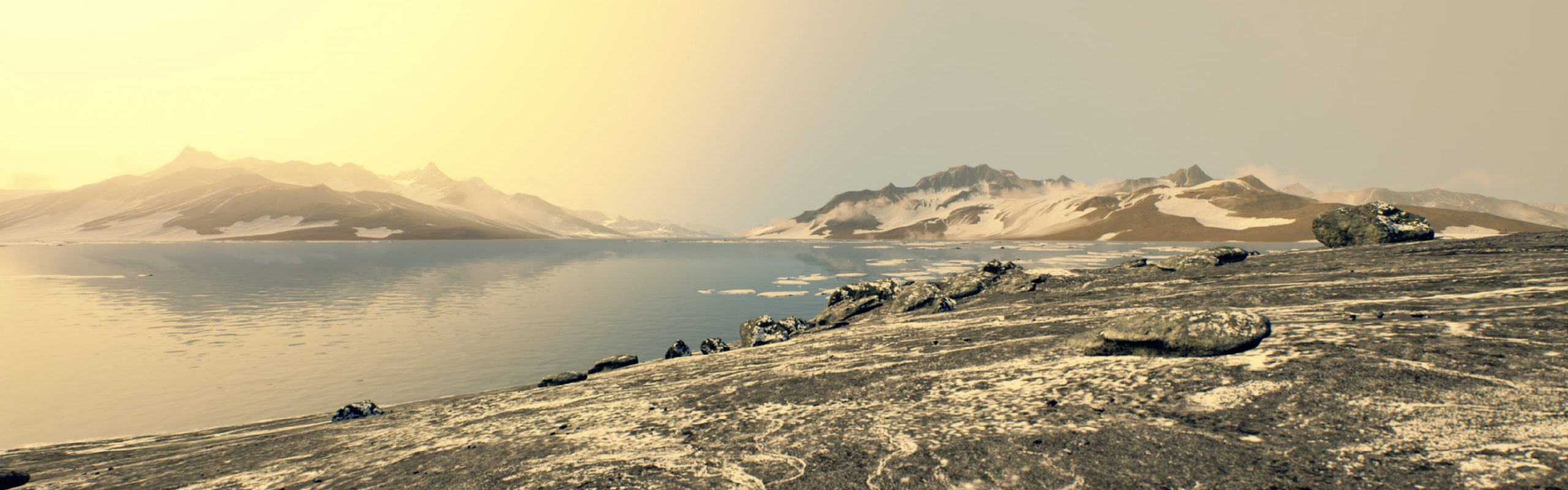
To give you some idea of the size of Antarctica it’s about twice the size of Australia and one and a half times the size of the USA. There are never more than about 5000 people from all nations there at any one time.
Field Work
All of my work involved working ‘in the field’ throughout the Antarctic summers, that is to say, hundreds of mile away from the base where I lived. This was at a time when we still used dogs (huskies) for our main form of transport and so a typical field trip would involve me, my assistant, a sledge each and nine dogs in each team with a typical trip being between 4 to 6 weeks away from base, sleeping in a tent.
What was I Doing?
Much of the science that I was working on is still being carried out today but what has changed is the way that this data is collected, as today there is far greater use of aircraft and satellite to collect data rather than send people to travel many hundreds of mile away from base in what can be a risky environment, working ‘in the field’. I was involved in two scientific activities which I will explain below.
Land Surveying
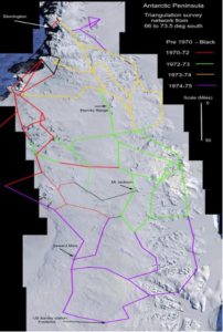
This involved me surveying (remember surveying = measuring) parts of the Antarctic peninsula which is the part of the Antarctic closest to South America. Land surveyors world-wide use the same techniques and methods of recording their data, this means that if someone uses my survey books/records let’s say, in five years time, then that surveyor should be able to understand my notes and to re-create my survey work.
To this end, when we are surveying a large piece of land we divide it up into a framework of triangles or areas that can be made into triangles and we then measure the length of the triangle sides and the angles of the sides of the triangles, in fact the Ordnance Survey have divided the entire of the UK into such triangles. I’ve provided two examples shown below of a survey of the Antarctic peninsula (shown earlier in the article).
 .
. 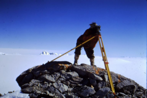
Image: Surveying in the Antarctic using a Theodolite
In the UK, the Ordnance Survey map the UK using the same principles that I used in the Antarctic. That is to say that the OS (Ordnance Survey) divide the UK into 6190 ‘Trig points’ short for ‘Triangulation Points’. Just the same way that I divided my survey up into triangles. This form of surveying is called Geodetic Surveying.
Trig points established by the OS also establish a height above sea level. As the sea level is not constant throughout the UK, the OS use the sea level at Newlyn in Cornwall for consistency.
Geophysics
Although not a geophysicist by profession I was given some training in this science before I departed for the Antarctic. What this activity entailed was to determine the nature of the rock formation of the Antarctic landmass below glaciers which were sometimes a mile deep.
The Science
This was achieved by using two pieces of scientific equipment.
1. a gravity meter
2. a proton magnetometer
As we all know, the earth has a gravity field which is a force which has a downward pull. What you might not know is that the strength of the gravity force is not a constant force but varies all over the world for a number of reasons. For example, if there is a metallic or dense ore contained in the rock strata then this will affect the gravitational force (pull) at that point.
In fact, archaeologists use this science to discover where long lost buildings can be unearthed and excavated. This is because although ancient walls may be lost under several foot of soil, the gravitational ‘pull’ where the walls are buried will differ from other farmland.
The method
An area for study would be identified by our headquarters back in the UK and we would be asked to go and survey this chosen area. Sometimes this was not always possible for safety reasons because when we’d sledged out to a particular area then sometimes crevasses had opened up making travel unsafe. In this case we would radio UK and ask for alternative areas.
Having selected a suitable area to survey, we would travel backwards and forwards using a grid pattern and would take gravity readings etc at various points so that a pattern for the gravitational force could be identified. Unfortunately, I never saw the end product of my work as I was the one doing the field work and collecting the data but the analysis was carried out by UK based scientists at Cambridge University.
Navigation
I was in the Antarctic before SATNAV and GPS was in wide use and so we used a navigational technique called ‘Dead Reckoning’. This method of navigation was common with ships and aircraft before SATNAV and GPS were in common use.
We knew the exact position of our starting point (the base on which we lived) in Latitude and Longitude. So, if on our first day of travel we’ve travelled 23 miles on a compass bearing of 135 degrees, then mathematically, I can calculate where I am in relation from where I started from. How did we know how far we have travelled? This brings me back to the cycle wheel on the back of the sledge. It’s fitted with a milometer and so I can read off how many miles I’ve travelled that day, and I know the direction from taking a compass bearing. Therefore I can calculate where I am relative from where I set off from.
Getting Re-supplied on a Field Trip.
We used very much the same system as the early explorers such as Scott and Shackleton in that we went out on short trips in advance of our main field trip and laid depots of food and supplies in the area that we were going to work in, so that we could work our way around an area going from depot to depot for food and fuel. One of the reasons for Scott’s party dying was that the solder that sealed the joints on the fuel cans reacted badly with the extreme cold and leaked. So when Scott arrived at a depot, instead of finding full cans of fuel for heating and cooking, they were all nearly empty.
During the Antarctic summer, we had the use of two small aircraft and these could re-supply us when working in the field.
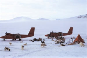
Image: Being re-supplied by air.
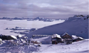
Image: Finally after a long trip, Home sweet Home! (Base T ‘Adelaide’) Note the frozen sea ice and trapped icebergs.
Steve Wroe
‘Semi’ retired University Lecturer, Polar Surveyor

Download PDF
If you wish to save, or print, this article please use this pdf version »
Learning resource
We have created learning notes to assist students and educators to further investigate the topics covered in this article. You can download the learning resource here »
